Construction Project Monitoring System Capstone Project
Purpose of the Project
The focus of this Capstone project is to improve the process of monitoring the status and updates of construction projects. The system will improve data storing and management. The system will provide calendar of activities which will help to improve the communication among the system users. Only the administrator can update data and manage the system.
Database Design
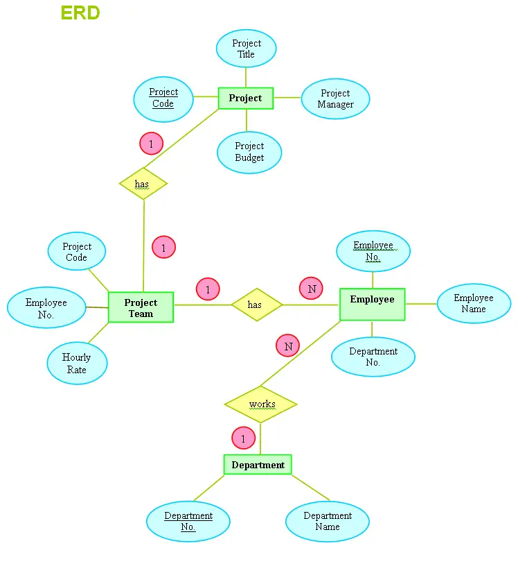
The given construction data are based on the given Normalized Form to be converted into an Entity Relationship Diagram that has an entity labelled Project having a corresponding attributes labelled Project Code (the primary key), Project Title, Project Manager and Project Budget that has a relationship with the Project Team labelled (has), with a corresponding attributes labelled Project Code (a Foreign Key, from entity Project), Employee No. (also a Foreign Key, from entity Employee), and Hourly Rate that also has a relationship with the Employee labelled (has) with the attributes labelled Employee No. which is the primary key of the entity Employee, Employee Name and Department Name (Foreign Key, primary key of entity labelled Department) that has a relationship with the entity labelled Department labelled (works) with a corresponding attributes labelled Department No. (primary key) and Department Name.
Therefore, given data’s of the Entity Relationship Diagram is all based on the information listed in the normalized form that requires to be reliable, updated, relevant and easily accessible in order to achieve the demand for information that requires new approaches in which data should be identified, collected, stored, retrieved, managed, analysed, communicated and presented in order to consider the complexities in developing, updating and processing data.
CHAPTER II
REVIEW OF RELATED LITERATURE, STUDIES, AND PRIOR ART SEARCH
This chapter contains the review of related literature of the proposed system which also consists of related studies. For further understanding of the study, the researchers made use of the different reading materials related to the proposed system. The materials are books, thesis, and other related website articles in addition to the knowledge of the researchers. These also guided the researchers to achieve the target objectives by getting ideas on other similar studies and make improvements as possible.
Related Literature
A GIS-based methodology for safe site selection of a building in a (hilly region)
According to Bansal(2011) suggested that the use of GIS for retrieving information from a database can assist architects or engineer in decision making. The use of GIS has already been explored in site selection; however, SSS using GIS has not been investigated in depth. Site selection of a building in hilly regions where topography plays a major role cannot be done without geospatial modelling and analysis capabilities that are available in GIS. (www.sciencedirect.com)
A web-based geographical project monitoring and information system for the road and highways
According to Anon (2016) the department of public Works and Highways is the executive department of the Philippine government responsible for all the projects in the field of public works. It is responsible for the maintenance of the Philippine road network and irrigation system. DPWH is also responsible for collecting, storing, retrieving, managing, analysing and presenting the data to the public. Many development projects have serious dependence on transport network. Authentic information on the transport infrastructure is fundamental requirement for many decision making process. (www.sciencedirect.com)
AVALANCHE Mapping: GIS for Avalanche Studies and Snow
Science
According to Douglas Scott (2009) “almost all avalanche and snow-profile data observations have been recorded as hard copies with no digital spatial component”. Technology advances now make it possible to bring observations and data into a GIS for referencing, modelling, and sharing. Historical hand-drawn avalanche path data is converted to digital GIS data, then loaded into a database that can be related to the original hard-copy occurrence, snow profile, and weather data. These data layers can be displayed over other GIS base layers such as DEM, DRG, DOQ, NAIP, soils/geology, and vegetation cover. Then integration of real-time weather and snow-profile data can be added for analysis. Digital data-collection tools can load new data directly into the GIS database. Historical avalanche-path data consists of archived records, photographs, hard-copy mapping of starting zones, and the extent area of danger. (www.avalanchemapping.org)
GIS for Climate Change
According to Jack Dangermond et al (2010) reducing the risks caused by climate change is an immense challenge. Scientists, policy makers, developers, engineers, and many others have used geographic information system (GIS) technology to be better understanding the complex situation and offer some tangible solutions. A GIS-based framework helps us to gain a scientific understanding of earth systems at a truly global scale. Stopping deforestation and growing new forests, particularly in the tropics, are the easiest and fastest ways for society to reduce carbon dioxide in the atmosphere and mitigate global warming. GIS is the one of the key elements of the forest carbon monitoring systems needed by tropical developing countries to manage their forest. GIS systems are in place for forest monitoring, and they can also be used to established and maintain property rights and land tenure and to the economic development. (www.esri.com)
Using Geographic Information System to Match Local Health Needs with Public Health Services and Programs
According to Tamara Dubowitz (2011) Local health departments (LHDs) play an important role in ensuring essential public health services, such as monitoring community health, informing and educating the public, and developing policies and plans that support individual and community health efforts. Geographic information system (GIS) technology offers a promising means for LHDs to locate community health needs, match them with services and programs, and ultimately identify any geographic gaps between areas of need and the reach of public health services. (www.gov.com)
Business Permit and Monitoring System
According to this site (www.inettutor.com) (2016) in local government units, Mayor’s Office is the regulating and monitoring division that assesses from small scale, medium and large scale businesses within the area of responsibility. Pertinent laws are implemented to regulate businesses and monitoring is regularly done by the office. However, there are still businesses that operate without proper permission from the authority. This problem is difficult to trace in the mayor’s office lists of businesses that are permitted and not permitted to operate due to the fact that their files are stored in a manual storage facilities. It also observed that, the office has a manual list of corresponding amount of fees per business. The use of Business Permit and Monitoring System with DSS alleviate these problems. With the system, it will twist and do a little change in processes of securing permits and monitoring businesses. Some features of the system such as registration of the businesses name, types of business and location; it also computes licenses fees. Storage facility will now become reliable and access of data and information will be easier. Moreover, the system can easily track or browse list of registered businesses that license is expired and about to be renewed. The system gives warning and notification for expired business licenses and automatically computes for fines. It has also a capability to compare data graphically, such as categories of business; small scale, medium scale and large scale and make comparisons so that decision makers will have an idea to better facilitate permitting and monitoring procedure. Once, installed and operational, it would be beneficial to the revenues of the city as well as to the business owners of the city. (www.inettutor.com)

Developing a Geographic Information System for the Upper Delaware Scenic and Recreational River
According to Shannon L. Thol (2016) Natural resources afforded by rivers and adjacent land areas have inherent spatial qualities that make them well suited for monitoring using geographic information systems (GIS). Such riparian areas are usually subject to certain spatial regulations and are often overseen by multiple authorities, further supporting the use of GIS in their management. The main goal of this project was to develop a GIS to support resource management at the Upper Delaware Scenic and Recreational River (UPDE), a unit of the National Park Service and the National Wild and Scenic Rivers System that surrounds the northernmost stretch of the Delaware River in Pennsylvania and New York. A web-enabled GIS was created for use by Park Service personnel and their collaborators from the region. The system integrates natural resource data with information on land use regulations and zoning in a way that supports the “project review” process used to guide management activities at UPDE. A secondary goal of this project was to use the knowledge gained during system development to devise a framework for incorporating GIS into the routine management of riparian areas, especially at Wild and Scenic Partnership Rivers. This framework is a process-oriented outline intended to help personnel with little to no GIS experience design and develop a system that supports their resource management needs. UPDE’s GIS and the framework both have potential to promote effective and efficient management of riparian resources in the Upper Delaware region and beyond (www.gis.eeducation.psu.edu)
Prior Arts
GIS Application for Local Government Revenue Mobilization
According to Collins Fosu and George Ashiagbor (2016) “as part of decentralization reforms, many countries have devolved revenue and expenditures responsibilities to Local Government Authorities (LGAs). LGAs therefore, face the challenge of mobilizing appropriate level of revenue to enable effective service and infrastructure provision. To ensure effective execution of these statutory functions, the Local Government Authorities (LGAs) all over the world need to improve their Internal Revenue Mobilization”. The GIS technology can enhance revenue mobilization and describes comprehensively the functionalities of GIS Application, Local Government Revenue Mobilization System (LGRMS), developed for local authorities in Ghana for internal revenue mobilization. It gives detailed information of the developed functionalities of the application and the dependencies on GIS for effective local government revenue planning and mobilization. The paper clearly shows that an integrated GIS-Database technology tool is capable of providing a more efficient collection, tracking and management of Local Government revenue and other municipal fees. The development of the revenue system is implemented by the use of the system development life cycle. The system provides realistic information on the revenue potential of an assembly and automates the revenue mobilization processes. It has the ability to integrate and analyse a wide variety of information based on their spatial locations. It also supports a full range of business process on revenue mobilization ranging from, billing, license applications and renewals, permits issuance etc. and the tracking of the same. The menu driven GUI developed is user friendly and incorporates various spatial utility maps including education and health facilities and road network which will increase its acceptability and utilization among planners and decision-makers and is expected to increase the efficacy of revenue planning and budgeting. (www.researchgate.net)
Synthesis
Based on research, the above mentioned are existing studies similar to our research study. It has the ability to integrate and analyse a wide variety of information based on their spatial locations. The GIS provides a strong framework for managing these types of systems with full transaction support and reporting tools. Using GIS Mapping it is capable of providing more efficient collection of data, managing and tracking of building location.