Online Reservation of Cemetery with Map Navigation
The project entitled Online Reservation of Cemetery with Map Navigation is an online database system that provides an easy way of record information and capabilities of managing mass collection of data and information. It also provides a database environment for the proper management of data. And it can provide location and field guidelines in a cemetery site through the mapping system.
In terms of recording information the cemetery management is still using a manual process in all of its transactions. The management had a difficulty in looking for the files or records. Some crucial issues like security, data loss, data storage, deceased persons records, and exact location of the deceased persons is one of the biggest problems in using a manual system. And other problem of the office, in terms of field guidelines they use manual map. And in terms of information the relatives of the deceased persons had a problem in getting information about the grave location.
In order to solve the above stated problems, the management of the cemetery together with the researchers decides to develop an information system that will convert manual processes into a database driven application to provide the clients a much better service and to reduce and eliminate the problems caused by a manual processing of transactions.
Literature
Municipal utility mapping system and method
The computer system and method provides a community map of a plurality of types of utility resources. Software displays a graphic map with visual references to a plurality of types of utility resources. The software also includes instructions that associate data relating to instances of the utility resources and display the data on the display. The method of creating a community map of a plurality of types of utility resources involves associating a plurality of maps of utility resources into a single graphic representation, associating related data with each utility resource; and providing a link between positions on the graphic representation and the associated data that enables display of the associated data when a position on the graphic representation corresponding to a utility resource is activated.
Features of the System by user type
Administrator
– Login, Logout , Change Password
– Can add, edit, delete, and deactivate account Staff
– Can View Account information and Deactivate Account
– Map Location Management
– Can add, edit, and delete Map Coloring Price
– Can Update Contact Details
– Can Backup Database
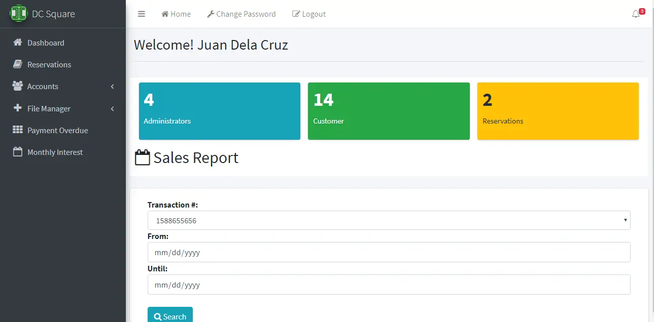
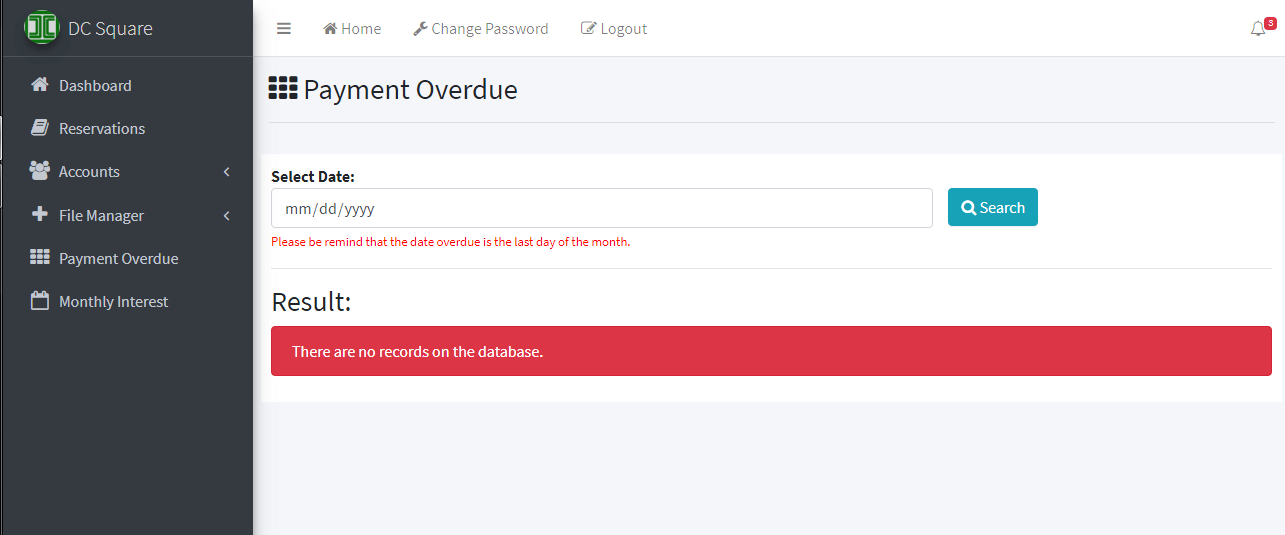
– Can notify the payment overdue of the customer
– Can See the Monthly Interest Rate of the system
– Can View the sales report per Customer or per Map
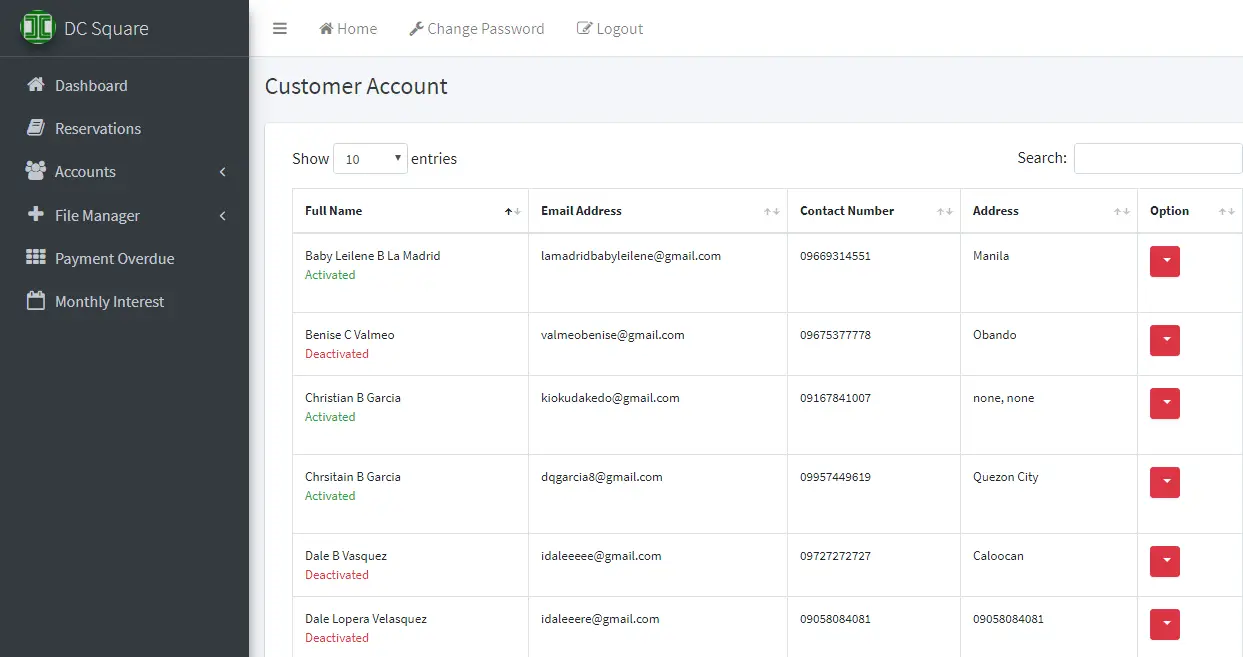
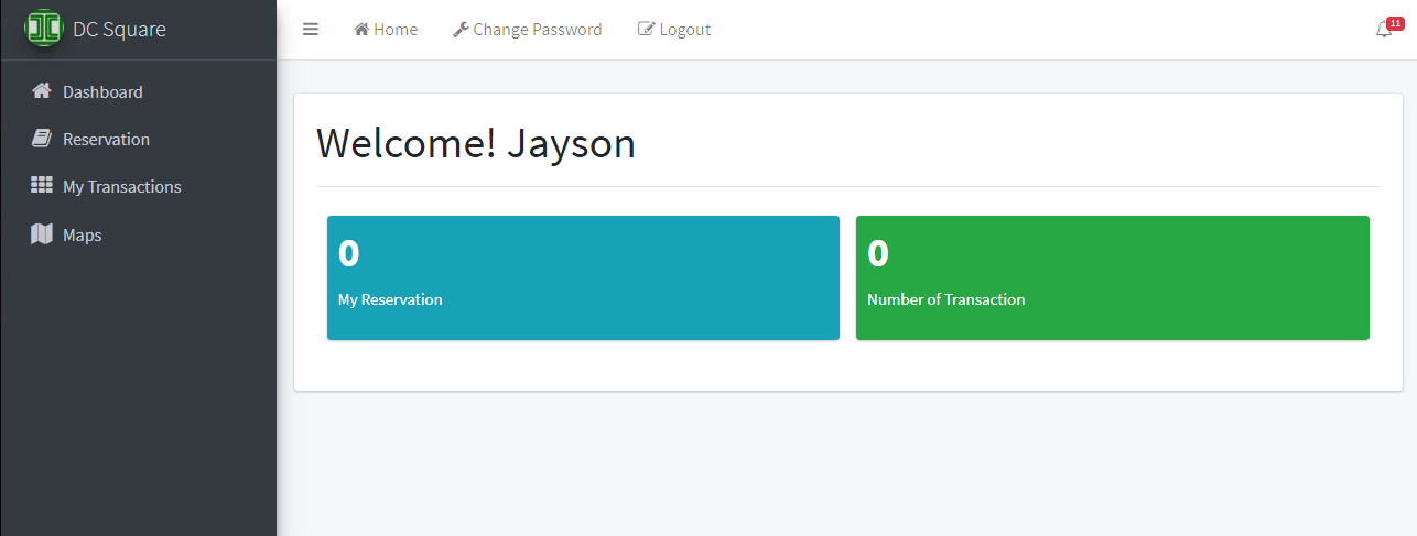
Customer / Member
– Login, Logout, Change Password
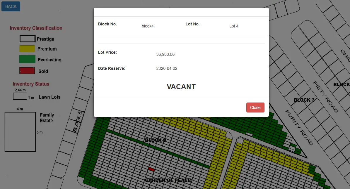
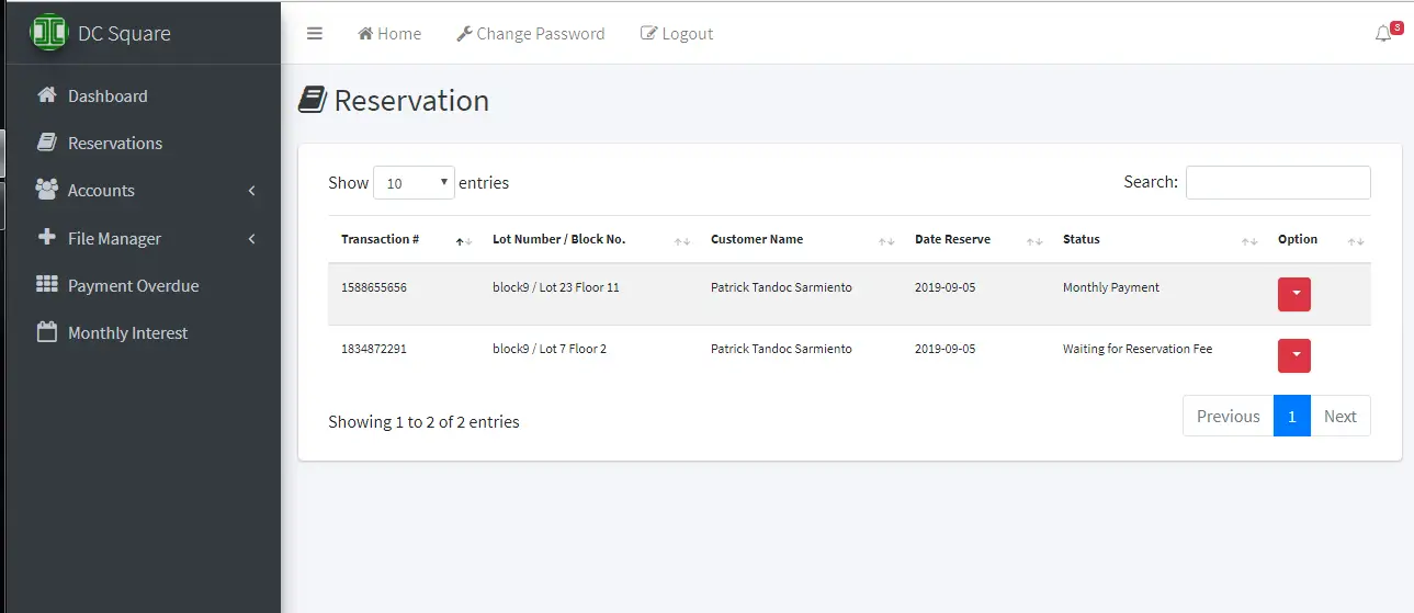
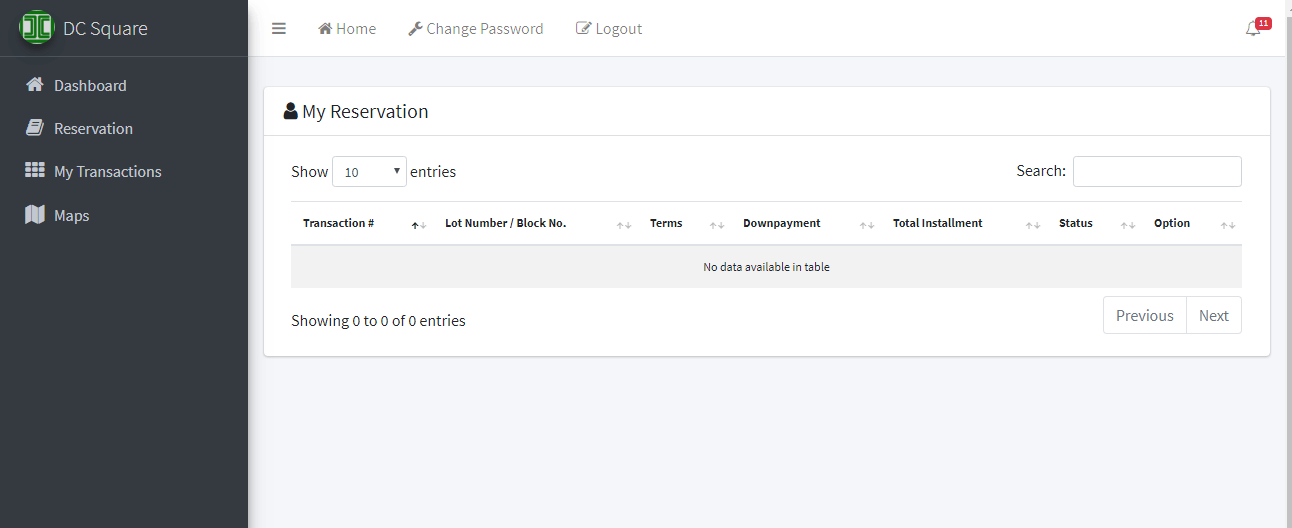
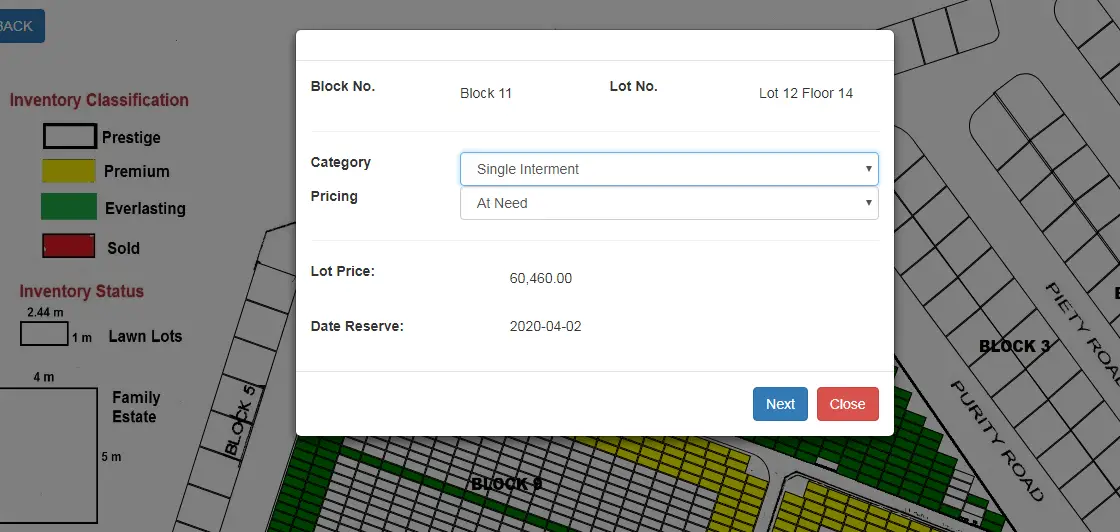
– Can apply for reservation of Cemetery / Nitio
– Can notify if there is a payment overdue using SMS notification and Email notification
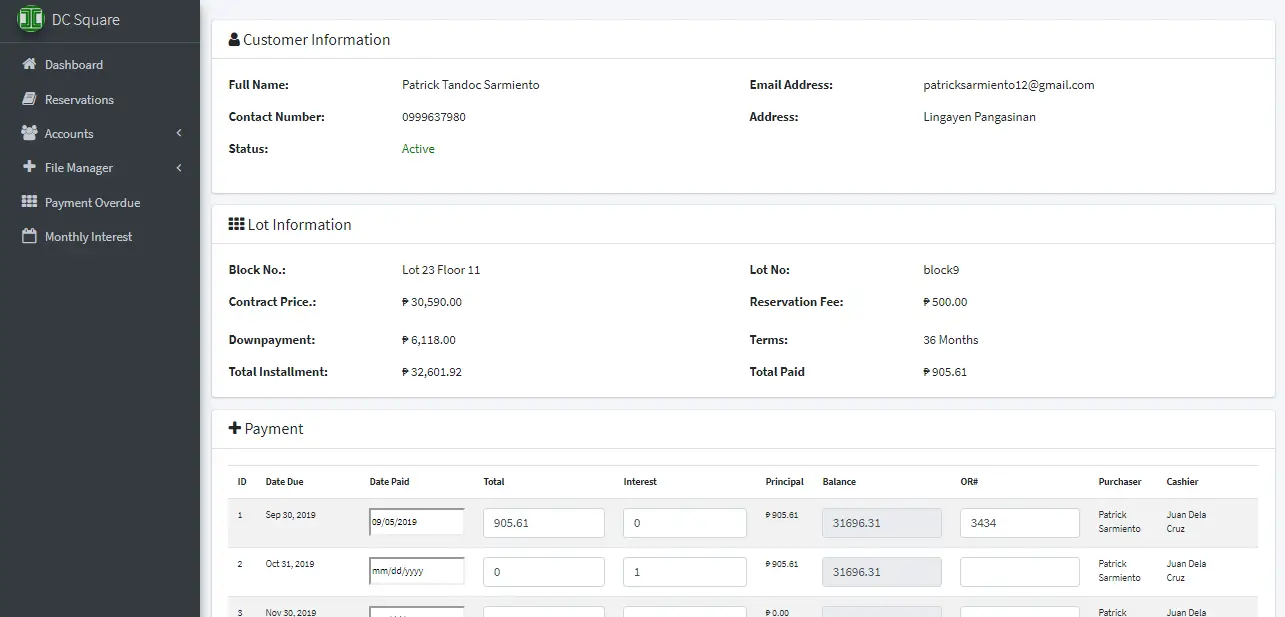
– Can See the Transaction History
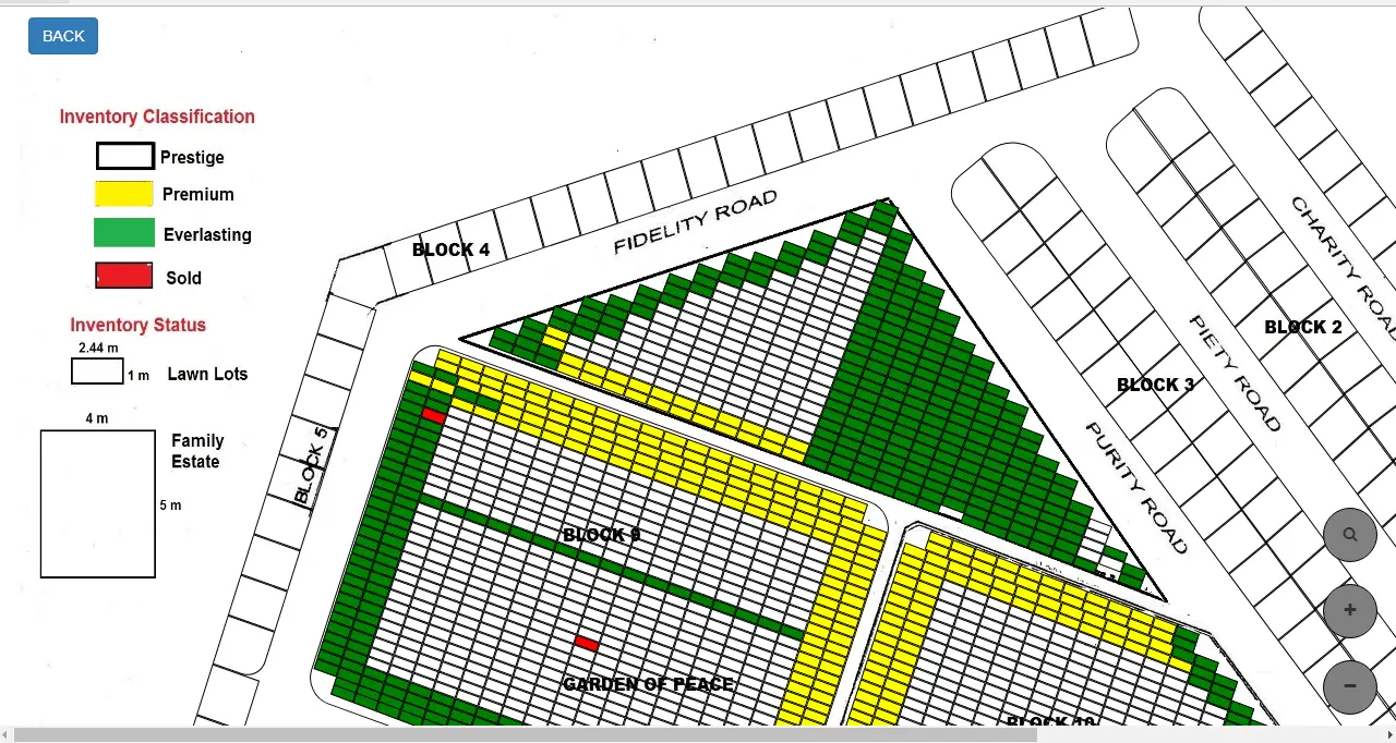
– Can view, zoom in, and zoom out the Map
– Can Sort the map per block
How the project works
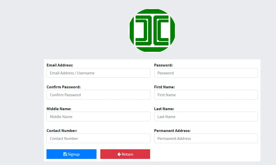
The system can be accessed by the cemetery management and the customers/clients. The customer needs to register its personal information (full name, address, contact, email address). Once the account has been activated, the customer can now login, view the vacant block/lot and apply for reservation of nitio. The transaction will be validated by the management and notify the customer via email or sms for the payment process. Necessary documents required must be complied to complete the transaction. With the simplified process, the management can monitor the payment overdue and reports of sales can be generated in a matter of time.
Screenshots of the project

Technicality of the project (Development Tools/Programming Languages used)
Hardware Requirement
The recommended specifications for the development of the system:
Laptop
Processor : Intel(R) Core(TM)i3-2310M CPU @ 2.10GHz (4 CPUs), ~2.1GHz
Memory : 4 GB of RAM
Software Requirement
UWAMPP: is a Wamp Server with Apache MySQL PHP and SQLite, and it comes with a very smart interface that offers various information, configuration and commands for the server. It can handle multiple php versions and monitor CPU usage. Also it is able to run in U3 mode (alternativeto.net).
Operating System (OS): a program that, after being initially loaded into the computer by a boot program, manages all the other programs in a computer. The other programs are called applications or application programs. The application programs make use of the operating system by making requests for services through a defined application program interface (API). In addition, users can interact directly with the operating system through a user interface such as a command line or a graphical user interface (GUI) (whatis.techtarget.com).
Brackets: an open-source editor written in HTML, CSS, and JavaScript with a primary focus on web development. It was created by Adobe Systems, licensed under the MIT License, and is currently maintained on GitHub. A bracket is available for cross-platform download on Mac, Windows, and Linux (en.wikipedia.org).
Google Chrome Browser: is based on the open source Chromium project. Google released Chrome in 2008 and issues several updates a year. It is available for Windows, Mac OS X, Linux, Android and iOS operating systems. The Google Chrome browser takes a sandboxing-based approach to Web security. Each open website runs as its own process, which helps prevent malicious code on one page from affecting others (or the computer operating system at large). The browser also supports Web standards such as HTML5 and cascading style sheets (CSS) (searchmobilecomputing.techtarget.com).
Bootstrap: a free and open-source front-end library for designing websites and web applications. It contains HTML- and CSS-based design templates for typography, forms, buttons, navigation and other interface components, as well as optional JavaScript extensions. Unlike many web frameworks, it concerns itself with front-end development only. (searchmobilecomputing.techtarget.com).
QGIS (previously known as Quantum GIS): is a free and open-sourcecross-platform desktop geographic information system (GIS) application that supports viewing, editing, and analysis of geospatial data. QGIS functions as geographic information system (GIS) software, allowing users to analyze and edit spatial information, in addition to composing and exporting graphical maps. QGIS supports both raster and vector layers; vector data is stored as point, line, or polygon features. Multiple formats of raster images are supported and the software can geo-reference images (en.wikipedia.org).
Leaflet: the leading open-source JavaScript library for mobile-friendly interactive maps. Weighing just about 38 KB of JS, it has all the mapping features most developers ever need. Leaflet is designed with simplicity, performance and usability in mind. It works efficiently across all major desktop and mobile platforms can be extended with lots of plugins, has a beautiful, easy to use and well-documented API and a simple, readable source code that is a joy to contribute to (en.wikipedia.org).
JavaScript: a cross-platform, object-oriented scripting language. It is a small and lightweight language. Inside a host environment (for example, a web browser), JavaScript can be connected to the objects of its environment to provide programmatic control over them.
System Design and Methodology
Analysis and Quick Design
During Analysis and Quick Design, the researchers did a personal interview with the respondents and the chosen client where the study was conducted. The respondents were given the chance to suggest how the system will be designed. After conducting the data gathering, the researchers made an initial design for the proposed system.
Data Analysis
The researchers will analyze all the data, user requirements and information. This phase also help the researchers to have an idea on how to create the system and have an idea on how the proposed system would be beneficial to the clients.
System Design
The researchers will start to develop the proposed system. It includes the design; how the system would look like based on user requirements, and the researchers/programmer would like to add personal design to make the system more interactive and user friendly.
Prototype Cycle
This stage will include the compiling, building, demonstration also refinement of the data gathered by the researchers. The researchers first build a prototype based on the planed design and data tables. After building the prototype it will be demonstrated to the client. The researchers show the function of the system, the flow on how it works, and the functions of the features that are included in the system. The last stage is refinement where in the researchers will refine the system by client’s additional needs. This will include changes in features flow and functions based on the requirements.
Testing
This will include the feed backing of the proposed system after it will be implemented and had undergone testing by three Experts. It will also inform the researchers and the developer if there are any bugs, suggestion and if the system’s functionality will works well.
Implementation
This will discuss the implementation of the propose system wherein Three (3) Experts will evaluate the propose system. This will also discuss if the recommended functions and suggestion are met. The last part is to turn over the project to the clientele with proper training and technical support.
for the sourcecode and documentation you may contact the developer of the system
Patrick Tandoc Sarmiento
09999637980
https://web.facebook.com/ptsarmiento