Logistics and Delivery Optimization Using GIS and AI: Building Smarter Delivery Platforms
Table of Contents
- Logistics and Delivery Optimization Using GIS and AI: Building Smarter Delivery Platforms
- Understanding Logistics and Delivery Optimization
- The Role of Geographic Information Systems (GIS)
- 1. Visual Route Planning
- 2. Distance Calculation
- 3. Traffic and Geographic Constraints
- 4. Location-Based Analytics
- The Role of Artificial Intelligence in Logistics
- Predictive Route Optimization
- Demand Prediction
- Delivery Time Estimation
- Intelligent Dispatching
- Concept of a Logistics Optimization Online Platform
- System Architecture Overview
- 1. Frontend Interface
- 2. Backend Application
- 3. GIS and AI Integration Layer
- Key Features of the System
- Delivery Route Optimization
- Interactive GIS Mapping
- Delivery Scheduling
- Real-Time Vehicle Tracking
- AI-Based Dispatching
- Delivery Status Monitoring
- Data Analytics Dashboard
- Benefits of GIS and AI in Logistics Systems
- Improved Delivery Efficiency
- Reduced Operational Costs
- Better Customer Satisfaction
- Smarter Decision Making
- Scalability
- Application in E-Commerce and Supply Chain
- E-Commerce
- Food Delivery Services
- Courier and Parcel Services
- Agricultural Supply Chains
- Security and Data Protection
- Challenges in Developing the System
- Data Availability
- Integration Complexity
- Computational Requirements
- User Adoption
- Future Trends in Smart Logistics
- Autonomous Delivery Vehicles
- Drone Deliveries
- Real-Time AI Decision Systems
- Internet of Things (IoT) Integration
- Conclusion
In the modern digital economy, logistics plays a crucial role in ensuring that goods move efficiently from suppliers to consumers. As online commerce continues to grow, businesses face increasing pressure to deliver products faster, cheaper, and more reliably. However, traditional logistics systems often struggle with issues such as inefficient route planning, fuel consumption, traffic congestion, and poor delivery coordination.
To address these challenges, many organizations are now turning to technology-driven solutions. One promising approach is the development of a Logistics and Delivery Optimization System powered by Geographic Information Systems (GIS) and Artificial Intelligence (AI). This type of online platform enables logistics companies, delivery services, and supply chain managers to analyze geographic data, optimize delivery routes, and make smarter operational decisions.
In this article, we explore how GIS and AI can be integrated into an intelligent logistics platform, how the system works, and why it is becoming increasingly important for modern transportation and delivery operations.
Understanding Logistics and Delivery Optimization
Logistics refers to the process of planning, implementing, and controlling the efficient movement and storage of goods. In the context of delivery services, logistics management involves coordinating drivers, routes, vehicles, packages, and delivery schedules.
Delivery optimization focuses on improving this process by minimizing travel distance, reducing operational costs, and ensuring that deliveries arrive on time.
However, achieving this level of efficiency is not easy. Logistics managers must consider multiple variables such as:
- Traffic conditions
- Distance between locations
- Delivery time windows
- Vehicle capacity
- Fuel consumption
- Weather conditions
Handling these variables manually or with basic systems can lead to inefficiencies and delays. This is where GIS and AI technologies become valuable tools.
The Role of Geographic Information Systems (GIS)
A Geographic Information System (GIS) is a technology used to capture, store, analyze, and visualize spatial or geographic data. In logistics systems, GIS plays an essential role in mapping delivery routes and understanding geographic relationships between locations.
GIS allows the platform to display maps, delivery points, warehouse locations, and transportation networks in a visual interface. Instead of simply listing addresses in a table, users can see delivery routes plotted on an interactive map.
This provides several advantages:
1. Visual Route Planning
Delivery managers can easily visualize routes between warehouses, distribution centers, and customer locations. This helps identify the most efficient path for delivery vehicles.
2. Distance Calculation
GIS tools can calculate the actual distance between locations using road networks rather than straight-line estimates.
3. Traffic and Geographic Constraints
GIS data can incorporate real-world constraints such as traffic congestion, road closures, and restricted zones.
4. Location-Based Analytics
Logistics managers can analyze patterns such as areas with high delivery demand, frequent delays, or inefficient routes.
By integrating GIS into a logistics platform, companies gain a powerful tool for spatial analysis and route visualization.
The Role of Artificial Intelligence in Logistics
While GIS provides geographic insights, Artificial Intelligence (AI) enhances the system by enabling intelligent decision-making and automation.
AI algorithms can analyze large amounts of delivery data to find patterns and recommend optimized routes.
Here are several ways AI improves logistics systems.
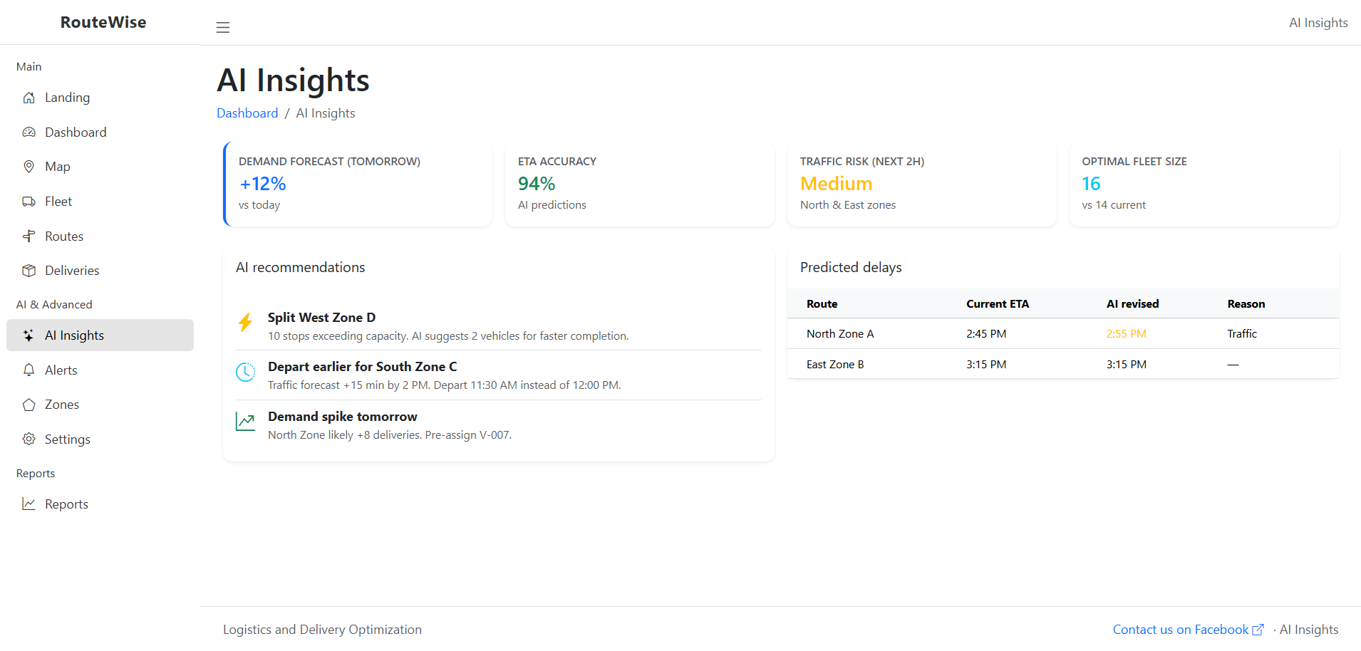
Predictive Route Optimization
AI can analyze past delivery data, traffic patterns, and geographic conditions to determine the most efficient routes.
Instead of simply calculating the shortest path, AI considers multiple factors such as travel time, traffic congestion, and delivery priorities.
Demand Prediction
Machine learning models can forecast delivery demand in specific areas. This allows companies to prepare vehicles and drivers ahead of time.
Delivery Time Estimation
AI can estimate accurate delivery times based on real-time conditions and historical delivery records.
Intelligent Dispatching
AI can automatically assign deliveries to drivers based on proximity, workload, and vehicle capacity.
This level of automation reduces human error and significantly improves operational efficiency.
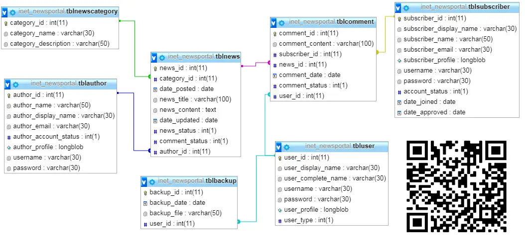
Concept of a Logistics Optimization Online Platform
A Logistics and Delivery Optimization Platform is typically developed as a web-based system accessible to administrators, logistics managers, drivers, and customers.
The platform centralizes delivery data, route planning, and logistics analytics in a single system.
Below are the main components of such a platform.
System Architecture Overview
The platform usually consists of three major layers:
1. Frontend Interface
The frontend provides the user interface where users interact with the system. It may include:
- Dashboard for logistics managers
- Map-based route visualization
- Delivery status tracking
- Order management panels
Frontend technologies commonly include HTML, CSS, JavaScript, and frameworks like React or Vue.
2. Backend Application
The backend handles business logic, data processing, and system integration. It performs tasks such as:
- Route optimization algorithms
- Delivery scheduling
- Data management
- AI model integration
Backend development may use technologies like PHP, Python, Node.js, or Java.
3. GIS and AI Integration Layer
This layer integrates geographic data and intelligent algorithms into the platform.
GIS services may include:
- Map APIs
- Location geocoding
- Distance calculations
AI components may include:
- Route optimization algorithms
- Predictive delivery models
- Intelligent driver assignment systems
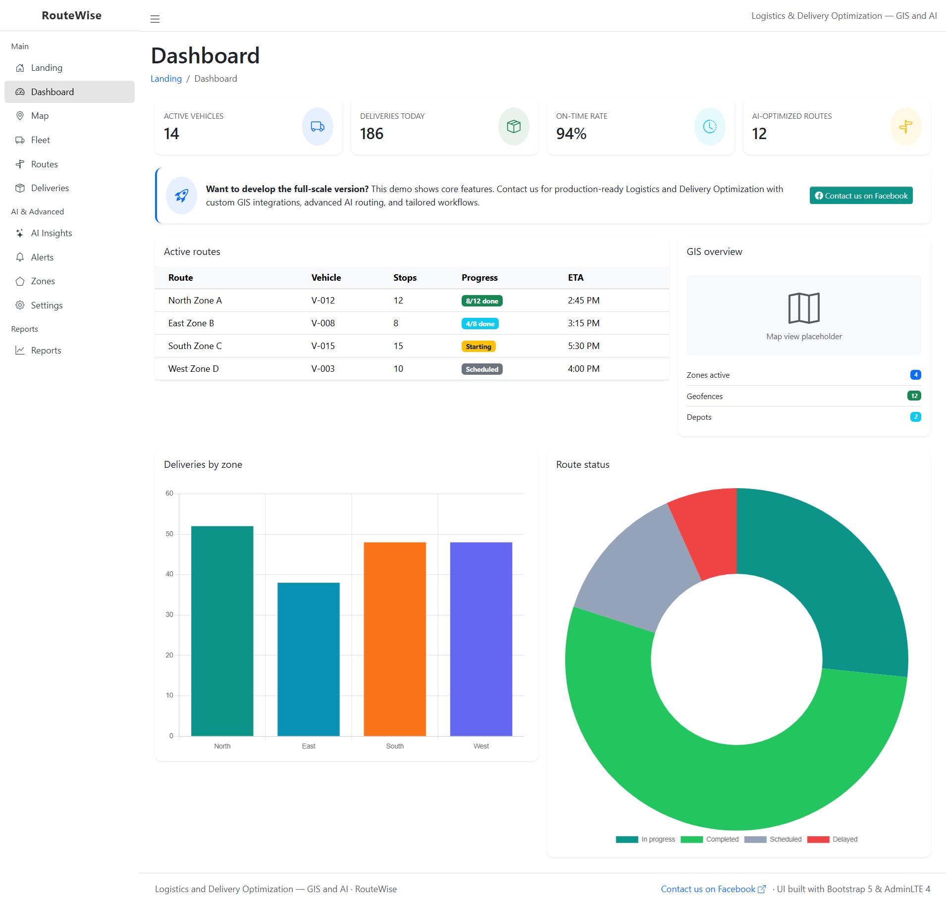
Key Features of the System
An effective Logistics and Delivery Optimization platform should include several important features.
Delivery Route Optimization
The system automatically calculates the most efficient delivery route based on distance, traffic data, and delivery priorities.
This helps drivers reduce travel time and fuel consumption.
Interactive GIS Mapping
A built-in map interface allows managers to view delivery locations, track vehicle movement, and monitor routes in real time.
Delivery Scheduling
Managers can schedule deliveries based on time windows and vehicle availability.
Real-Time Vehicle Tracking
The system can integrate with GPS devices or mobile applications to track delivery vehicles in real time.
AI-Based Dispatching
AI algorithms can automatically assign orders to the most suitable delivery driver.
Delivery Status Monitoring
The platform allows administrators and customers to monitor delivery progress through status updates.
Data Analytics Dashboard
Managers can analyze key performance indicators such as:
- Average delivery time
- Driver efficiency
- Fuel consumption
- Delivery success rate
These insights help companies improve logistics strategies.
Benefits of GIS and AI in Logistics Systems
Integrating GIS and AI into logistics platforms provides significant advantages for businesses and delivery operations.
Improved Delivery Efficiency
Optimized routes reduce unnecessary travel and allow drivers to complete more deliveries within a shorter period.
Reduced Operational Costs
Better route planning leads to lower fuel consumption, fewer vehicle maintenance issues, and reduced labor costs.
Better Customer Satisfaction
Accurate delivery time estimates and real-time tracking improve customer experience and trust.
Smarter Decision Making
Analytics and AI predictions help logistics managers make informed decisions about fleet management and delivery scheduling.
Scalability
The platform can easily scale as delivery operations grow.
Application in E-Commerce and Supply Chain
This type of logistics optimization platform is highly valuable in industries such as:
E-Commerce
Online retailers rely heavily on efficient delivery systems. Optimized logistics ensures fast shipping and reliable service.
Food Delivery Services
Food delivery companies require real-time route optimization to ensure timely delivery.
Courier and Parcel Services
Courier companies can manage thousands of deliveries more effectively using intelligent route planning.
Agricultural Supply Chains
Farmers and distributors can use logistics platforms to transport products efficiently from farms to markets.
Security and Data Protection
Since logistics platforms manage sensitive data such as customer addresses and operational information, strong security measures must be implemented.
These may include:
- Secure authentication systems
- Role-based access control
- Data encryption
- Secure APIs for GIS and AI services
Proper security ensures that the platform remains reliable and protects user information.
Challenges in Developing the System
Although the benefits are significant, developing a GIS and AI-based logistics platform also presents several challenges.
Data Availability
Accurate geographic and traffic data is necessary for effective route optimization.
Integration Complexity
Integrating GIS services, AI models, and logistics operations can be technically complex.
Computational Requirements
AI algorithms may require significant processing power for large-scale logistics networks.
User Adoption
Organizations must train staff and drivers to properly use the system.
Despite these challenges, the long-term advantages of intelligent logistics platforms make them worthwhile investments.
Future Trends in Smart Logistics
Technology continues to transform the logistics industry. In the coming years, we can expect further innovations such as:
Autonomous Delivery Vehicles
Self-driving delivery vehicles may become part of logistics networks.
Drone Deliveries
Drones can deliver small packages quickly in urban areas.
Real-Time AI Decision Systems
AI systems will become even more advanced in predicting demand and optimizing delivery networks.
Internet of Things (IoT) Integration
Smart sensors on vehicles and packages will provide real-time logistics data.
These advancements will continue to improve efficiency and reliability in logistics systems.
Conclusion
The integration of Geographic Information Systems (GIS) and Artificial Intelligence (AI) has the potential to revolutionize logistics and delivery operations. By combining spatial data analysis with intelligent algorithms, organizations can build powerful platforms that optimize routes, reduce costs, and improve delivery performance.
A Logistics and Delivery Optimization System not only benefits logistics companies but also enhances customer satisfaction by ensuring faster and more reliable deliveries.
As businesses continue to expand their online operations, the need for smart logistics solutions will become even more critical. Developing an intelligent logistics platform using GIS and AI is therefore a strategic step toward building a more efficient, scalable, and data-driven delivery ecosystem.
You may visit our Facebook page for more information, inquiries, and comments. Please subscribe also to our YouTube Channel to receive free capstone projects resources and computer programming tutorials.
Hire our team to do the project.